To say that this description will suit everyone is lying. But why? Because of the first six words: "Catalonia is a region of Spain". It is indeed a region of Spain according to laws and international treaties and all the worlds, understands Spain as a unit, a solid country. But the truth is that Spain is not such a unit. Spain is a diverse country, not because of its different and beautiful landscapes but because inside it, there are what we call "historical regions". This regions, which are, according to common law (the Constitution), Galicia, the Basqueland and Catalonia. Each of them has a language of its own and in the past they had been independent from Spain (until the 15th century). Besides, 19th century Europe saw the rise of nationalism, which attracted Catalan intellectuals of the time. This, among with some other things, make some Catalans feel that they do not belong to Spain. But more of it in another post. Let's focus on geography now :).
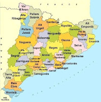
Now that the geographical limits of Catalonia have been established, I would like to talk about how is Catalonia internally divided.
 As any other part of Spain, Catalonia is divided into provinces. The four Catalan provinces are: Girona, Barcelona, Tarragona and Lleida. The capital city of these provinces bear the same name.
The provinces are further divided into what is called "comarques" (a kind of counties), which have, as in the case of provinces a capital city. Logically, the most populated of these capital cities becomes the province's capital.

